Denver Basin Geology and Background
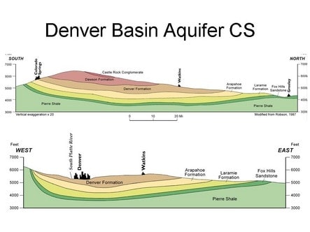
Douglas County residents primarily rely on the Denver Basin’s underground aquifer system for their fresh water supply. This system has four water-yielding layers designated as the Dawson, Denver, Arapahoe and Laramie-Fox Hills, shown below in two geologic cross-sections (CS). Comprised of sand and permeable sandstone formations, each is separated by layers of impermeable bedrock.

Courtesy of Colorado Geological Survey
The Denver Basin aquifers have long been an economical, quality source of fresh water for the county’s growing community. They are, however, defined as nonrenewable as there is no source of natural replenishment. Because water fills the pore spaces of these formations, scientists are unable to predict the behavior of the aquifer system as the resource is depleted.
Well monitoring data indicates that well production volumes and aquifer water levels are declining. The Colorado Division of Water Resources, also known by its traditional name, the State Engineer’s Office, has a wealth of resources, data and reports about the Denver Basin Aquifers on its web site. You can find an outline of the history and some of the intricacies of Denver Basin ground water rights on the State site, plus a detailed discussion of the water levels in the Denver Basin Aquifers.
The Colorado Division of Water Resources – Denver Basin | Division of Water Resources (colorado.gov)

